So, how was the North Wales Path? Here are some reflections on the Path as whole.
I can't help thinking that maybe this was meant to be walked East to West, not West to East as I have done. Certainly the Path divides into two distinct sections, either side of Conwy, and west is harder.
East of Conwy, this is a walk along the coastline, with occasional diversions inland. That means it is mostly low-lying and level, and can be quite dull when all you are doing is walking along a beach. It also means it is very accessible, with plenty of places to buy ice-creams etc. in summer, and really not much need to bring a picnic at any time because you are never too far away from shops.
West of Conwy, it is a hillwalk, and more strenuous. It mostly (though not always) looks down on the coast. As I have said, there is absolutely nowhere on the Path between Port Penrhyn and Conwy town walls where you can spend money, even if you wanted to.
Much of this path is very quiet indeed: I saw very few other walkers on the more rural stretches. I did see lots of dog-walkers and cyclists on some parts of the Path more suited to that. Aber Falls also is a popular destination.
Rail Access
This Path is made for rail access, which is how I did it. Conwy, Llandudno Junction, Deganwy, Colwyn Bay, Abergele and Prestatyn stations are virtually on the Path, with Bangor, Llandudno and Rhyl stations just a short walk away. At Llanfairfechan and Penmaenmawr, the access suffers slightly from the Path being on Snowdonia foothills and the stations being at sea level, but even then it's not too far.
Circular Walks
It's ocourred to me that parts of this Path couuld be done as circular walks:
Great Orme: the Great Orme circuit as I did, crossing back to where you started from Llandudno North shore to West shore. This could link back to Llandudno station.
Colwyn/Llanddulas: the inland part of the North Wales Path, doubling back along the coast cycle track.
Rhyl/Prestatyn: the inland part of the Path, returning along the shore: in a straight line; the additional distance between Rhyl and Presttayn is only 4 miles.
This Blog
I may have indulged my personal interests in (alphabetical order) Architecture, Geology, History, Ornithology, Prehistory and Railways; other people may have noticed different things; but then that only shows what different treats the walk has to offer.
Saturday, 12 November 2011
Wednesday, 9 November 2011
Rhyl to Prestatyn (16km/10miles)
To complete my walk, I started again at Rhyl station. I didn't exactly retrace my steps from last time to get back to the North Wales Path, but this time followed a path westwards alongside the railway line, which joined a road up towards a bridge but down again on the same side of the railway, veering right when it was no longer possible to go straight on, onto Seabank Road. This was a road of what must have been impressive Victorian guest houses. At a crossroads at the end of Seabank Road, the Marine Lake is to be seen straight ahead, but the North Wales Path crosses from right to left, and my route took me leftwards to a footbridge over the railway line.
 Here at the Glan Morfa Community Woodland it is possible to turn right towards the riverside, but I didn't do that as the Path goes straight on (although once again the signs had lost their plates and I had to confirm my route from the map). After passing a caravan site on the left, the Path enters fields and also turns towards the banks of river Clwyd. This is now a tarmaced cycleway all the way to Rhuddlan (the castle can be seen in the distance straightaway), on top of recently-rebuilt flood defences. There was much birdlife to be seen along the mudflats - Shelduck and Curlews in abundance and what might have been some sort of Grebe.
 Following the Path towards Rhuddlan is simple enough; after going under the modern road flyover it comes to an older road bridge which is where it turns left into the town, just before the castle.
I took some time to look round Rhuddlan, starting first with the graveyard around St. Mary's Church, whose most striking feature is a memorial by a local sculptor Lunt, which seems later to have become his memorial, too.
 Having not actually visited Rhuddlan Castle before, I would have liked to have gone round it, but it was closed for the winter. Instead, I took a path beyond the Castle (now diverting away from the North Wales Path) to Twt Hill, the site of the earlier, eleventh century, motte. Picture shows view looking down the river from Twt Hill.
 I doubled back to rejoin the Path which follows the High Street. Here is what claims to be the Parliament Building where the Statute of Rhuddlan was made. "No foundation for the tradition and inscription", says Hubbard in The Buildings of Wales: Clwyd. The Parliament is actually for sale.
Between Rhuddlan and Dyserth, the Path makes an effort to go off-road again, but it's a bit convoluted. There were enough North Wales Path signs to give occasional reassurance that I was not lost, but not enough to have been able to navigate the path using them alone. I usually keep my OS map in the backpack to check if I'm in doubt, but this time ended up carrying it my hand to check every turn. Detailed directions follow.
Leaving Rhuddlan, the Path follows a cycle route left at a roundabout, then crosses the road down Pentre Lane to the right. Out of the residential area, just after a bridge over a stream, it leaves the lane to cross a brief field to a footbridge, and across that field eventually to rejoin the same lane (so if you missed that bit, you wouldn't go far wrong). It continues across the lane along an untarmaced access track, which eventually gets to a pretty cottage in woods ('Cottage Covert' on the map). Just before the cottage, the Path leaves the access track to skirt round the covert and in to another field, where it follows the field boundary anti-clockwise. A short way after what was the right-hand corner, there is a stile on the right, with a generic footpath sign but no North Wales Path sign, where apparently you turn an obtuse angle so it almost feels like doubling back. Looking up confirms this is in fact the right way to get to Dyserth - aiming just to the left of the hilltop of Y Foel got me across the field to the right place, at the corner of Aberkinsey farm (which looks like it ought to be in Hubbard, but isn't). The Path turns left along the farm access road, then right along a bridle track (lots of horses here, also pheasants). Where the bridle track fords a stream, the Path turns left along a field edge towards Llewerllyd farm, which is some sort of animal rescue place. After that and crossing a stream, a stile into fields leads to the road into Dyserth. Following that road a very short way, the Path turns right.
 Dyserth was quite an entertaining village. It has a pretty little church, with one monument outside which dates back to 1676, then a famous waterfall (admission 40p in honesty box). It's not as dramatic as Aber Falls (seen earlier in my first instalment), but is surprisingly whooshy considering the little stream which runs from it.
 The village seems to be built on the side of a cliff. After the waterfall, I took a little footpath which goes up some steps by the side of the falls, rejoining the road which keeps the upward progress. There's a short High Street, then the road dips downwards as it begins to leave the centre. On the left, there's a bit of a carpark (mostly closed off when I was there). Here the North Wales Path joins the Prestatyn-Dyserth Way for its final stretch. In fact the Path finishes as it started, on a cycletrack laid on disused railway line. Most of today's walk had been on a flat floodplain then with a steep ascent - what was admirable about the railway engineering was how it conspired to even out the gradient all the way down the Prestatyn. And being on an old railway line, it fairly easily got me back to the main line and Prestatyn Station to get me home.
Verdict: Rhuddlan and Dyserth were interesting little places, and walking along an old railway line is almost an end in itself. Unfortunately, a dull day meant not so many interesting pictures.
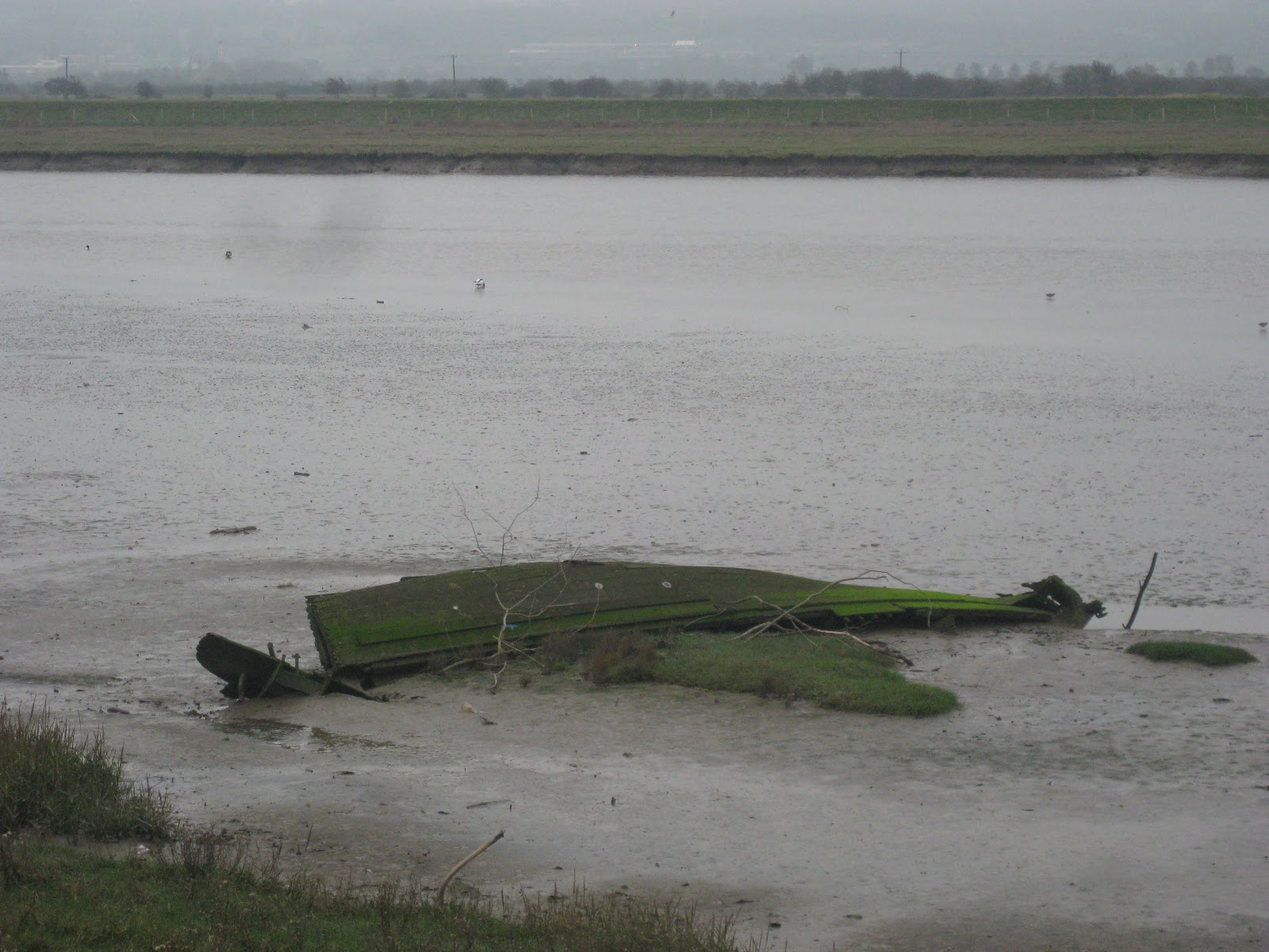 Here at the Glan Morfa Community Woodland it is possible to turn right towards the riverside, but I didn't do that as the Path goes straight on (although once again the signs had lost their plates and I had to confirm my route from the map). After passing a caravan site on the left, the Path enters fields and also turns towards the banks of river Clwyd. This is now a tarmaced cycleway all the way to Rhuddlan (the castle can be seen in the distance straightaway), on top of recently-rebuilt flood defences. There was much birdlife to be seen along the mudflats - Shelduck and Curlews in abundance and what might have been some sort of Grebe.
 Following the Path towards Rhuddlan is simple enough; after going under the modern road flyover it comes to an older road bridge which is where it turns left into the town, just before the castle.
I took some time to look round Rhuddlan, starting first with the graveyard around St. Mary's Church, whose most striking feature is a memorial by a local sculptor Lunt, which seems later to have become his memorial, too.
 Having not actually visited Rhuddlan Castle before, I would have liked to have gone round it, but it was closed for the winter. Instead, I took a path beyond the Castle (now diverting away from the North Wales Path) to Twt Hill, the site of the earlier, eleventh century, motte. Picture shows view looking down the river from Twt Hill.
 I doubled back to rejoin the Path which follows the High Street. Here is what claims to be the Parliament Building where the Statute of Rhuddlan was made. "No foundation for the tradition and inscription", says Hubbard in The Buildings of Wales: Clwyd. The Parliament is actually for sale.
Between Rhuddlan and Dyserth, the Path makes an effort to go off-road again, but it's a bit convoluted. There were enough North Wales Path signs to give occasional reassurance that I was not lost, but not enough to have been able to navigate the path using them alone. I usually keep my OS map in the backpack to check if I'm in doubt, but this time ended up carrying it my hand to check every turn. Detailed directions follow.
Leaving Rhuddlan, the Path follows a cycle route left at a roundabout, then crosses the road down Pentre Lane to the right. Out of the residential area, just after a bridge over a stream, it leaves the lane to cross a brief field to a footbridge, and across that field eventually to rejoin the same lane (so if you missed that bit, you wouldn't go far wrong). It continues across the lane along an untarmaced access track, which eventually gets to a pretty cottage in woods ('Cottage Covert' on the map). Just before the cottage, the Path leaves the access track to skirt round the covert and in to another field, where it follows the field boundary anti-clockwise. A short way after what was the right-hand corner, there is a stile on the right, with a generic footpath sign but no North Wales Path sign, where apparently you turn an obtuse angle so it almost feels like doubling back. Looking up confirms this is in fact the right way to get to Dyserth - aiming just to the left of the hilltop of Y Foel got me across the field to the right place, at the corner of Aberkinsey farm (which looks like it ought to be in Hubbard, but isn't). The Path turns left along the farm access road, then right along a bridle track (lots of horses here, also pheasants). Where the bridle track fords a stream, the Path turns left along a field edge towards Llewerllyd farm, which is some sort of animal rescue place. After that and crossing a stream, a stile into fields leads to the road into Dyserth. Following that road a very short way, the Path turns right.

 The village seems to be built on the side of a cliff. After the waterfall, I took a little footpath which goes up some steps by the side of the falls, rejoining the road which keeps the upward progress. There's a short High Street, then the road dips downwards as it begins to leave the centre. On the left, there's a bit of a carpark (mostly closed off when I was there). Here the North Wales Path joins the Prestatyn-Dyserth Way for its final stretch. In fact the Path finishes as it started, on a cycletrack laid on disused railway line. Most of today's walk had been on a flat floodplain then with a steep ascent - what was admirable about the railway engineering was how it conspired to even out the gradient all the way down the Prestatyn. And being on an old railway line, it fairly easily got me back to the main line and Prestatyn Station to get me home.
Verdict: Rhuddlan and Dyserth were interesting little places, and walking along an old railway line is almost an end in itself. Unfortunately, a dull day meant not so many interesting pictures.
Wednesday, 2 November 2011
Colwyn Bay to Rhyl (20km/14miles)
 I resumed the walk on a good sunny day, starting off from Colwyn Bay station, going back under the railway underpass to the east of the station to rejoin the North Wales Path at Colwyn Bay pier. Some major building work on the sea wall meant I had to walk on the inland side of the promenade road for a while, before crossing over to walk more along the coast itself.
Soon, the road swings right under viaducts beneath first the railway then the A55, while a path and cycle route carries on along the coastline. Now, I had thought up to now that the new Wales Coast Path followed the line of the North Wales Path exactly along its length, but here the Wales Coast Path sign points straight on along the cycle route, but a glance under the viaducts shows the North Wales Path sign diverting inland. The inland route is the right way, but I could have been misled here by following the Wales Coast Path sign. It did occour to me later that the coastal cycle route, joined up with the inland stretch of this path, could make a good circular walk.

The Path now follows the Colwyn river upstream, initially through a small public park, where this 1894 folly stands. Approaching the Abergele Road, the old main road before the A55 expressway was built, path and river pass under it in two parallel tunnels.
 I carried on, past an attractive row of houses along the riverside, up a few steps to a road where the Path very briefly leaves the river's edge, before rejoining it through the 'Fairy Glen'. The path continues along the east side of the river, climbing a little above it in the wooded shallow gorge of the Fairy Glen, following the line of what must be a former mill leat. The Path emerges on a road to turn rightwards, then shortly afterwards turns left into a golf course.
 Despite signs to remind us of the dangers of golf, and common-sense courtesy to other users, it really isn't obvious at first which way the walker should take through the course. After consulting my map, I went upwards along a boundary to my left, then turned right along a line of trees, which succesfully got me to a Path sign at an exit into a minor road. The Path here crosses the minor road and enters another part of the golf course. This time it's more or less uphill at right angles to the road just left, towards another sign on a trackway, where I turned leftwards and upwards.
 A signpost gives us a choice of public paths, where our path turns right, follows the right-hand field edge downwards then turns left (a reassuring arrow here) to follow the far field edge towards a little footbridge over a stream, and stile. The Path crosses the next field to a woodland, although it really isn't obvious where the woodland should be entered until you're right there. There are the semblance of many paths through this wood, but what turned out to be the correct one is more heavily used, and has occasional square posts which have lost their sign plates.
 There follows another field, another wood, another field, another wood, and again the signing isn't perfect but the square posts confirmed I was on the right lines. The last woodland path is downhill into a small valley which then joins a track up round the opposite side of the valley where suddenly we are into limestone quarry territory. Nipping round some farm buildings, the path now follows Bwlch-y-Gwynt Road towards the village of Llysfaen and this Baptist chapel building.
 I followed the North Wales Path sign on a track to the right, which then goes over a stile into a field. After climbing gradually most of the time since leaving the coast, the Path is now on a limestone plateau (not quite limestone pavement) with a sweeping view inland, overlooking a swath of agricultural land of the Dulas valley. The path goes more or less straight on along the side of this plateau, but again all the posts (see picture) had lost their little sign plates, so although I could affirm I was on the Path, I couldn't always be sure which way to go next. But to give credit where it is due, I did later on come across contractors engaged in replacing and renovating signs and stiles.
 As the river Dulas below me swang north to the shore, the Path too swings leftwards to follow the valley side. The view here is of Plas Newydd earthworks on the west side of the valley in the foreground, Pen-y-Corddyn hillfort on the east side opposite, the Clwydian range on the horizon.
 I followed a roughly parallel line before joining an old quarry road down to rejoin the North Wales Path. This then crosses a couple of fields and down a narrow pathway past a loudly barking dog, opening out onto the old main road through Llanddulas, a handsome village of local limestone.
I took time here to visit St. Cynbryd's church and a very tidy graveyard. There is also a large and striking village hall (pictured).
The Path crosses the main road and over the bridge, then follows a roadway down towards the beach.
A short way along from Llanddulas, an information board refers to the Honeycomb Worm Reef here. The tide being high at the time, I wasn't able to see this interesting natural feature.

 From Llanddulas to Rhyl, following the North Wales Path for seven miles or so is very straightforward indeed as it simply follows the shoreline, which as it is all shingle beach to the left and a sea wall protecting low lying land doesn't give a great deal of variety. The first stretch has the railway and A55 immediately to the right, then as the expressway swings inland, it got a little quieter, as out-of-season caravan parks, amusement arcades and holiday centres took its place. At Towyn you can see where the sea wall was hurriedly rebuilt when the sea encroached in 1990. Along the shore later on there was much sea holly, and hundreds of oystercatchers and dunlin, also this interesting little bird (pictured). After some conferring, this is identified as probably a Snow Bunting.
 Finally the Path reaches Rhyl across the blue Foryd Bridge. I found my way to the railway station through back streets signposted as a cycle route there.
Verdict: The inland stretch was by far the most interesting part of this walk, and it's shame it wasn't as well marked as, say, the Anglesey Coastal Path, which is why I've written up the route in more detail. The long walk along the sea wall didn't add much; I can see that this makes a good way for cyclists, pushchairs or wheelchairs but for a walk, well, one mile was much like another.
Subscribe to:
Comments (Atom)